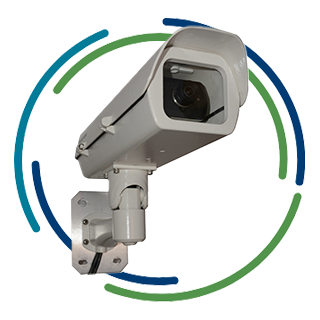
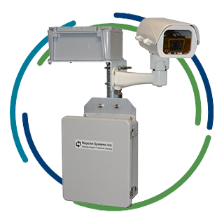
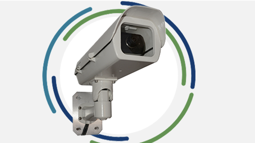
Aerimis remote environmental monitoring systems
will keep you in the picture anywhere in the world
![](https://www.nupointsystems.com/wp-content/uploads/2024/03/Aerimis-Graphics-nupoint-fixed-sight.png)
True global coverage for monitoring the effects of climate change using the Iridium satellite network
Observe the effects of climate change in real time with an Aerimis system
![Trees in a flooded field](https://www.nupointsystems.com/wp-content/uploads/2023/04/aerimis-group-598.png)
![Climate change icon](https://www.nupointsystems.com/wp-content/uploads/2023/04/aerimis-group-664-2.png)
Climate Change Monitoring
An invaluable tool used by scientists and environmentalists to manage global warming monitoring.
![Smoke rising from forested area](https://www.nupointsystems.com/wp-content/uploads/2023/04/aerimis-group-599.png)
![Trees Icon](https://www.nupointsystems.com/wp-content/uploads/2023/04/aerimis-group-276.png)
Wildfires
A wildfire monitoring system designed to save time, money, and our forests.
![Glacier field in the mountains](https://www.nupointsystems.com/wp-content/uploads/2023/04/aerimis-group-600.png)
![Snowflake icon](https://www.nupointsystems.com/wp-content/uploads/2023/04/aerimis-layer-2-copy-2.png)
Water, Ice, and Snow
Effectively monitor and collect critical data of water levels and ice and snow conditions of your remote locations.
![Cabin surrounded by trees on a small island](https://www.nupointsystems.com/wp-content/uploads/2023/04/aerimis-group-601.png)
![Airplane Icon](https://www.nupointsystems.com/wp-content/uploads/2023/04/aerimis-group-313.png)
Remote Travel Safety
Keep travelers safe by monitoring weather, road, rail track, and airstrip conditions in remote destinations.
IRIDIUM SATELLITE NETWORK FOR GLOBAL CONNECTIVITY
Clients we serve
![BC Hydro logo](https://www.nupointsystems.com/wp-content/uploads/2023/06/aerimis-nu_bc-hydro.png)
![Fisheries and Oceans Canada logo](https://www.nupointsystems.com/wp-content/uploads/2023/06/aerimis-nu_fisheries-_-oceans.png)
![Environment and Climate Change Canada logo](https://www.nupointsystems.com/wp-content/uploads/2023/06/aerimis-nu_enviro-_-climate-change.png)
![Last Frontier Heliskiing logo](https://www.nupointsystems.com/wp-content/uploads/2023/06/aerimis-nu_last-frontier-heli.png)
![Parks Canada logo](https://www.nupointsystems.com/wp-content/uploads/2023/06/aerimis-nu_parks-canada.png)
![Simon Fraser University (SFU) logo](https://www.nupointsystems.com/wp-content/uploads/2023/06/aerimis-nu_sfu.png)
![Teck Resources Ltd Logo](https://www.nupointsystems.com/wp-content/uploads/2023/06/aerimis-nu_teck.png)
![Temsco Helicopters Inc Logo](https://www.nupointsystems.com/wp-content/uploads/2023/06/aerimis-nu_temsco-heli.png)
![University of Alaska Logo](https://www.nupointsystems.com/wp-content/uploads/2023/06/aerimis-nu_uoa.png)
![US Forest Service Dept of Agriculture Logo](https://www.nupointsystems.com/wp-content/uploads/2023/06/aerimis-nu_us-forest-service.png)
![US Geological Survey Logo](https://www.nupointsystems.com/wp-content/uploads/2023/06/aerimis-nu_usgs.png)
![US National Park Service Alaska Logo](https://www.nupointsystems.com/wp-content/uploads/2023/06/aerimis-nu_us-park-service-01.png)
![Water Security Agency, Saskatchewan Logo](https://www.nupointsystems.com/wp-content/uploads/2023/06/aerimis-nu_wsa.png)
![Yukon Territory Logo](https://www.nupointsystems.com/wp-content/uploads/2023/06/aerimis-nu_yukon-gov.png)
Partners we work with
Remote Viewer FS
![](https://www.nupointsystems.com/wp-content/uploads/2024/03/Aerimis-Graphics-Remote-Viewer-FS-camera-3-parts.png)
Globalstar remote monitoring solution for North America
Recent blog posts
Why Iridium became the satellite network of choice for Nupoint’s global remote monitoring solution
Nupoint partnered with Iridium shortly after the introduction of the Certus 100, and early in 2024, we launched our global satellite camera, Aerimis.
Located in Northwestern British Columbia, within Tahltan Territory, approximately 110 kilometers southwest of Dease Lake, the Galore Creek Project boasts a rich history.
Mount Meager remote monitoring update: Cameras pointed at glacier caves
The Mount Meager massif is a group of volcanic peaks located 150 km (93 mi) north of Vancouver at the northern end of the Pemberton Valley and reaches a maximum elevation of 2,680 m (8,790 ft).
1Except where prohibited by law or local regulation. Aerimis cameras are also available for cellular (international coverage).
2Globalstar North American coverage does not include far north in Canada.