About Mount Meager and the Centre for Natural Hazards Research (CNHR)
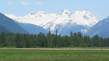
The Mount Meager massif is a group of volcanic peaks located 150 km (93 mi) north of Vancouver at the northern end of the Pemberton Valley and reaches a maximum elevation of 2,680 m (8,790 ft). The massif is capped by several eroded volcanic edifices, including lava domes, volcanic plugs, and overlapping piles of lava flows; these form at least six major summits, including Mount Meager, which is the second highest of the massif with a long history of eruptions.
The Centre for Natural Hazards Research (CNHR), located within the Department of Earth Sciences at Simon Fraser University, includes more than 30 partners and experts from across British Columbia, as well as from other national and international institutions. Its mandate is to conduct innovative training and research on geophysical processes that are a threat to the population and economic infrastructure of Canada.
Challenge
While the Mount Meager massif has remained dormant for over 2,400 years, the potential volcanic hazards, ranging from landslides to eruptions, pose a significant risk to the surrounding region, including humans and wildlife. An explosive eruption around 2,400 years ago resulted in avalanches of hot ash, rock fragments, and volcanic gases, forming Keyhole Falls on the northeastern flank. Recent signs of volcanic activity, such as hot springs and earthquakes, underscore the ongoing geological dynamics. The massif has also been the source of major landslides, including a substantial debris flow in 2010, the largest in Canada, affecting Meager Creek and the Lillooet River.
Given these risks, the challenge is to establish effective monitoring systems for Mount Meager to ensure preparedness in the face of potential eruptions or landslides, safeguarding both human and wildlife populations. This concern was particularly heightened during the heat dome of 2021.
Solution
In the summer of 2020, Nupoint Systems met with Dr. Glyn Williams-Jones, Professor and Department Chair of Earth Sciences and Co-Director of the CNHR, and donated to the CNHR its first remote camera system to monitor the activity of Mount Meager. Due to the heat dome of 2021 and a subsequent landslide, Nupoint provided a second remote monitoring camera system the the team. Dr. Glyn Williams-Jones reported, “We were particularly interested in two potential hazards on the same site, the unstable mountainside and the formation of ice caves, and utilized the Nupoint Systems remote cameras to monitor these areas.”
Unstable mountainside
Previous orbital satellite studies have indicated this mountainside is moving. The scientists increased the frequency of photographs taken by the Nupoint Systems satellite camera from daily to every hour and provided updates to the Ministry of Emergency Management and Climate Readiness as well as Sea to Sky Corridor Rangers with eyes on the situation. The concern was that the heat dome would increase melting and water flow into this unstable mass and trigger an event. The setup also involved a series of sensors attached to a weather station, using the Nupoint satellite telemetry system, and also a seismometer sending info via radio. Thankfully, no large failure occurred—avoiding a catastrophe for the moment.
Ice caves
Scientists have observed volcanic gases forming up from fumaroles (sulphur-rich emissions that come up through fractures). The Nupoint Systems remote monitoring camera was used to monitor how the glacier responded to the heat dome and other climate changes. The CNHR has been awarded a Trebek Initiative/National Geographic grant to support the exploration of these ice caves, which contain toxic gases, to be carried out by an expert team of search and rescue cavers. Armed with proper breathing equipment, the objective of the research is to identify the sources of this gas. A team from NASA’s Jet Propulsion Laboratory, expanded the research utilizing engineered robots, looking for extreme bacteria that exist in these horrible conditions. Dr. Glyn Williams-Jones also reported, “During the heat dome we saw a minimum of three to five meters of ice loss in a two-month period. The glacier is receding incredibly quickly, and having the camera send regular snapshots of activity is a valuable resource.”
The Canadian Natural Hazards Knowledge Portal
The team at CNHR is developing the Canadian Natural Hazards Knowledge Portal, a one-stop shop for information that is accessible to the Canadian public, administrators, scientists, academics, educators, corporate partners, and government decision-makers to enhance preparedness and response. Imagery captured by the Nupoint Systems cameras will be loaded directly to this portal and accessible to all users who can benefit from it. These economical satellite images are complementary to telemetry (which can be limited by topography), video that requires high, expensive bandwidth, or orbital satellite data that is only available every 12 days.
Multiple images are worth a million words
“It is impossible to stop natural hazards,” says Dr. Glyn Williams-Jones. “What we hope to do is mitigate the impact, and the way to do that is to know about it. When we have the information in advance, we hope to be able to forecast events with some level of confidence to allow us to provide warnings and, for example, say, evacuate.”
The advent of the Nupoint Cameras has given scientists ‘eyes on’ information that formerly was not available. And Emergency Management and Climate Readiness BC recognized the cameras were doing the lion’s share of the monitoring of this slope, an area which has the potential to be 10x greater than the 2010 slide.
“We are very excited about what we can do with the Nupoint camera systems. And thanks to Nupoint for donating the first one. Having corporate partners working collaboratively with local governments, we can take massive steps forward. As they say, an image is worth a thousand words, and multiple images are worth a million words,” says Dr. Glyn Williams-Jones.